Author Archives: Casey

More Street Names

North – South Streets Sources: (1) The Streets of St. Louis: A History of St. Louis Street Names, by William B .and Marcella C.  Mahan. Virginia Publishing Company, St .Louis, MO  63108 © 1994, 1996. (Secondrevised edition)    (2)  St. Louis Public Library searchable online list compiled by Dr. Glen Holt and Thomas A.Pearson.

 KINGSHIGHWAY:  Kingshighway originated as an Indian trail to a portage on the Missouri River. White settlers called it the King’s Trace (or highway), as they called most roads running between the king’s land and the common fields.  (Le Rue de Roi for the French; El Camino Real for the Spanish).  It was the western boundary of the Prairie des Noyers Common Field.  It became the main stem of the Kingshighway Boulevard “system” adopted by the city in 1903. ( Source: Streets of St. Louis*)

At one time, there were many Kingshighways in St.  Louis:  Union Blvd. was “Second Kingshighway;” Bircher Blvd. was “Kingshighway Northeast” or “Kingshighway-Bircher;”  Kingshighway Southwest” comprised Christy, Holly Hills and Bellerive boulevards, with the Christy stretch sometimes referred to as “Kingshighway-Christy.”  And “Grand Kingshighway” ran from Carondelet Park north to Bellerive Boulevard.  Today’s Kingshighway Boulevard run through eight neighborhoods:  Cabanne, Central West End, Clifton, Grand Prairie, The Hill, Oak Hill, Shaw and Southwest.

NORTH KINGSIGHWAY BLVD. was renamed KINGSHIGHWAY MEMORIAL BLVD. in 1922 to honor military heroes killed in World War I.  Kingshighway Memorial ran from Easton Ave. (now Martin Luther King, Jr. Dr.) to West Florissant Ave.  The ordinance has never been repealed, so Kingshighway Memorial still exists, running through the Arlington, Fairground and Walnut Park neighborhoods.

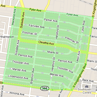
LAWN AVENUE Appeared between Oakland and Berthold avenues in the 1912 Forest Lawn Subdivision, it received its name from the subdivision. Neighborhoods: Oakland and Southwest. (St. Louis Public Library)

HEREFORD and SUBLETTE honor Mrs. Frances Hereford Sublette, wife of the fur and Indian trader, Solomon Sublette. Part of the Fairmount Heights Subdivision of 1868 was developed on Sublette family lands. Neighborhoods: The Hill, Oakland and Southwest. (St. Louis Public Library)  Frances’ first husband was William Sublette, who was appointed in 1845 by Thomas Hart Benton to be Superintendent of Indian Affairs in Washington, DC. On his way, he died; Frances eventually married his brother Solomon. (Streets of St. Louis)

BRANNON AVENUE was originally platted in the 1871 subdivision of St. Louis Heights and named for John B. Brannon, a city deputy sheriff in the 1850s. Neighborhoods: The Hill and Southwest. (Library)

SUBLETTE AVENUE appeared on St. Louis maps dating back to the 1850s. It was named in honor of William L. and Solomon B. Sublette, western fur traders who were landowners in Gratiot League Square. Portions of Sublette Ave. were also known as Cheltenham Avenue and Blue Ridge Road until 1881. It was Blue Ridge Road from Connecticut to Pernod until 1881. Neighborhoods: The Hill, Oakland and Southwest. (Library)

MACKLIND AVENUE began as St. Louis Avenue in the Fairmont Heights Subdivision of 1868. It was renamed in 1881 to honor of Thomas H. Macklind, district engineer of the city street department. Neighborhoods: The Hill, Oakland and Southwest. (Library)                                ###                ###         ###

How Our Streets Were Named

East-West Streets

CHIPPEWA:  Named for the Chippewa Indians.  Once it was called “Mine Road” west of Grand Ave., because it led to clay mines owned by fellows named Russell, Christy and Bingham – whose names live on in southside streets. (Source: The Streets of St. Louis: A History of St. Louis Street Names, by William B.and Marcella C. Manan. Virginia Publishing Company, St. Louis, MO  63108 © 1994, 1996. 2nd revised edition)

LINDENWOOD, MARDEL and OLEATHA:  A real-estate developer named Samuel Thomas Rathell was married to Oleatha Didawich, and asked her to name streets in an area he was developing in 1888. She named Oleatha for herself, Lindenwood for the college she had attended, and Marquette for her childrens’ school.  She had grown up on Delmar, to the north, and reversed the syllables to name Mardel.  Delmar had been named by two landowners, one from Delaware (Del), the other from Maryland (Mar). (Source: The Streets of St. Louis: A History of St. Louis Street Names)

THOLOZAN: Tholozan honors a merchant who married well.  One of the earliest inhabitants of St. Louis was a man named Gabriel Dodier (for whom a street in North St. Louis is named).  His son, Rene Dodier, sold some land near what is now Grand and Gravois, to Charles and Marie (Conde) Sanguinette, who eventually gave the land to daughter Adele, who was married to a storekeeper from France –John Eli Tholozan.  The Tholozans lived on the land for quite some time before selling it to South Side National Bank. The street behind the bank keeps the Tholozan name alive.(Source: The Streets of St. Louis: A History of St. Louis Street Names)

PERNOD:  Named for Aime R. Pernod (1783-1872), an early landowner.  It marked the southern boundary of a land grant in 1785 from the Spanish Lieutenant Governor to Charles Gratiot and his wife, Victoire Chouteau Gratiot.  The land grant totaled 5,712 acres, covering the area from what is now the middle of Forest Park on the north to Pernod on the south, and from Kingshighway on the east to Big Bend on the west. The acreage was called the Gratiot League Square. (Streets of St. Louis)   Pernod appeared on maps as early as 1856, according to a St. Louis Public Library searchable online list compiled by Dr. Glen Holt and Thomas A. Pearson.  It was known as Pernod Road from Kingshighway to Watson Road until 1893. Pernod’s tract eventually  became the Ivanhoe Park Subdivision in the  Southwest neighborhood.

MIAMI:  Named for the Miami River and the Miami Indian tribe of Ohio in the platting of the St. Louis Commons of the 1850s, according to the Library database. (Neighborhoods: Marquette-Cherokee, Oak Hill and Southwest)

POTOMAC:  In the St. Louis Commons subdivision of 1854 the street was named after Maryland’s Potomac River.  Potomac is an Indian word recorded as Potawameak by John Smith in 1608. Its meaning is “where goods are brought in.” It was called Scudder Avenue from Grand to Gustine until 1881. (Neighborhoods: Marquette-Cherokee, Oak Hill and Southwest) (Source: Library)

FAIRVIEW:  This street first appeared on St. Louis maps in the 1856 Robert W. Hunt Subdivision, between Grand and Gustine avenues. Its name was derived from the beautiful vista that could be seen from its elevated location. (Neighborhoods: Oak Hill and Southwest) (Source:. Louis Public Library)

PARKER:  Honors George Ward Parker, son-in-law and business partner of James Russell in the Parker-Russell Mining and Manufacturing Company. George was the husband of Rusella Lucy Russell, daughter of James Russell. Parker was platted in Lucy Bent Russell’s subdivision of 1884. Neighborhoods: Oak Hill and Southwest) (Source: St. Louis Public Library).  According to the book Streets of St. Louis, James Russell and his son-in-law George operated a coal mine at Morganford and Tholozan and a clay mine at Morganford  and Utah.

FYLER:   Commemorates James D. Fyler, an early landowner, in the subdivision of his estate in 1866. (Neighborhoods: Clifton, The Hill, Oakland and Southwest). (Source: St. Louis Public Library).